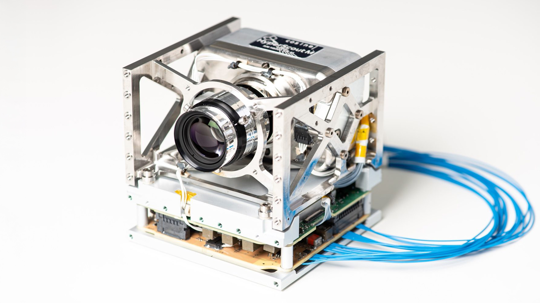
Scout Family of Instruments
Compact hyperspectral imaging instruments designed for small satellites.

Designed to deliver reliable insight in changing and demanding environments, Scout instruments combine scientific performance with flexibility, supporting missions where adaptability and trust are essential. Built as complete measurement systems, they integrate optics, detectors, electronics, and data handling into a single, reliable payload.
Product overview
Innovation at cosine is not a straight line. It is a disciplined loop where Scout instruments are compact, modular remote sensing systems that can be configured for different observation needs and platforms. By using a shared architecture, the Scout family balances customisation with reuse, enabling faster development while maintaining consistent performance and quality.

Compact hyperspectral insight for real-world missions

Spectral and thermal insight in one integrated system
Hyperspectral insight in a 1U CubeSat form factor

Focused thermal insight from compact satellite platforms

High-resolution thermal insight for demanding missions

High-resolution hyperspectral insight for detailed observation
Hyperspectral insight, optimised for small satellites
Advantages
The Scout family is designed to maximise insight under real mission constraints, combining compact form factors, wide coverage, onboard intelligence, and fast deployment into a single scalable solution.

Compact
Fully fledged hyperspectral camera that fits in a shoebox.

Artificial Intelligence
Smart data processing on board saves on download bandwidth.

Wide field of view
Capture more data with a swath of up to 300 km.

Early warning
Set your parameters to receive real-time warnings.

Short revisit times
Several visits per day possible with multiple HyperScouts.

Data fusion
Combine Sentinel-2 calibration and spatial resolution with HyperScout spectral resolution and revisit time.

Low cost
A constellation of HyperScouts for the price of one large instrument.

Fast delivery
Off the shelf in weeks or customized to your needs in 3 months.
Application examples
cosine’s remote sensing technology is designed for deployment both in space and in the atmosphere, enabling consistent measurement from satellites or unmanned aerial platforms such as drones.
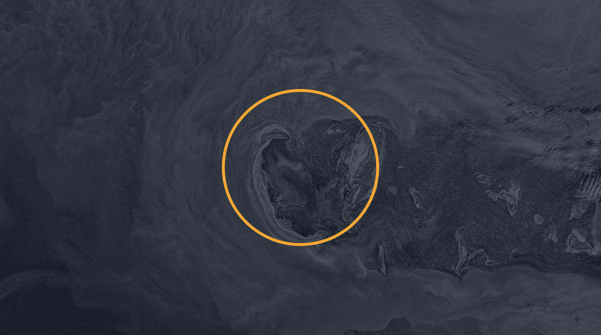
Algae detection
HyperScout can be configured to detect algae and monitor harmful blooms. This helps turn spectral signals into early insight that supports safer drinking water and protects ecosystems. The image shows coral reefs near Lucinda, Queensland (Australia), captured by HyperScout in October 2020.
Vegetation health
HyperScout can be configured to track vegetation condition across large areas. By translating changes in plant signals into reliable indicators, it supports environmental monitoring and better-informed decisions over time. The image shows Flevoland (the Netherlands), captured by HyperScout in November 2020.
Crop water requirement
HyperScout can be configured to monitor crop water requirement. This HyperScout can be configured to assess crop water needs by observing indicators linked to plant stress and moisture. This enables more targeted irrigation planning, helping farmers manage resources efficiently without losing visibility at scale. The image shows fields near Ceylanpinar, Turkey, captured by HyperScout in November 2018.
Flood delineation
HyperScout can monitor how flooded areas develop over time, with a HyperScout can be configured to map flooded areas and track how they evolve with high temporal resolution. By turning repeated observations into dependable situational awareness, it supports response planning and longer-term resilience efforts. The image shows the Gulf of Aqaba coastline (Saudi Arabia), captured by HyperScout in October 2020.
Change detection
HyperScout can be used for change detection. Applications vary from HyperScout can be configured to detect change over time across land and water systems. From pollution monitoring to deforestation and desertification tracking, it helps convert consistent observation into actionable insight where trends matter most. The image shows Moffett Field, California (USA), captured by HyperScout in November 2020.
HyperScout options
Your own HyperScout
Buy a standard HyperScout or we build you a customized HyperScout to fit your application needs.
New HyperScout observation data
We schedule dedicated observations using one or more HyperScouts already in orbit.
Existing HyperScout data
We extract data from earlier HyperScout observations and help you retrieve the information you need.
Fully analyzed HyperScout data
From HyperScout acquisition to data analysis: we provide you with the information you need.
Let's connect
Have a measurement challenge to explore?
Reach out and we’ll help you shape the right approach, clarify what matters, develop the solution, and build a reliable, real-world outcome. Let’s turn complexity into insight, together!